8 Most Impressive Natural Formations in Colorado
Complete guide to 8 most impressive natural formations in colorado. Detailed information, recommendations, and everything you need to know

Colorado's geological story spans nearly two billion years, creating a natural museum of Earth's most dramatic processes. From ancient seafloors thrust skyward to volcanic explosions that sculpted entire mountain ranges, the state showcases nature's raw power in ways that consistently leave visitors speechless. These formations aren't just pretty landscapes—they're windows into deep time, revealing how our planet has transformed through eons of upheaval, erosion, and rebirth.
What makes Colorado's natural wonders particularly striking is their accessibility combined with their scientific significance. You can stand where dinosaurs once roamed, touch rocks that formed when continents were mere fragments, and witness ongoing geological processes that continue shaping the landscape today. Each formation tells a unique chapter in Earth's biography, from the patient work of water carving impossibly deep canyons to wind sculpting massive sand dunes that migrate across valley floors. These eight remarkable sites represent the pinnacle of Colorado's geological heritage, offering experiences that connect us directly to the planet's most fundamental forces.
Garden of the Gods
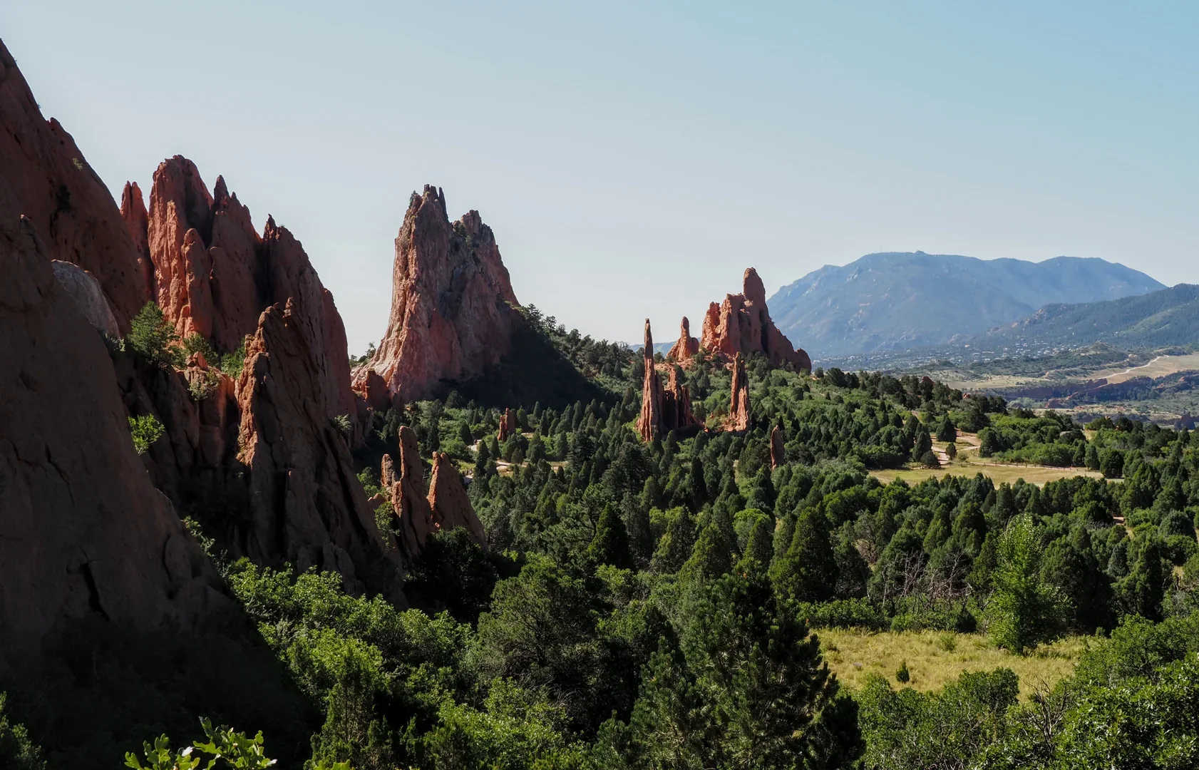
The towering red sandstone spires of Garden of the Gods create one of Colorado's most photographed landscapes, but their true magnificence lies in their geological complexity. These dramatic formations began as ancient sand dunes roughly 300 million years ago, when Colorado lay beneath a vast desert. Over millions of years, these dunes were buried, compressed into solid rock, then thrust vertically during the uplift of the Rocky Mountains approximately 65 million years ago.
The park's most iconic formation, Balanced Rock, demonstrates the delicate interplay between erosion and structural geology. This massive sandstone boulder perches precariously atop a narrower base, creating a formation that seems to defy gravity. The red coloration comes from iron oxide—essentially rust—that coated the original sand grains, while white layers indicate periods when the ancient environment contained less iron.
Walking through formations like the Three Graces or Cathedral Spires reveals the incredible forces that shaped this landscape. The rocks were tilted at steep angles during mountain building, creating dramatic fins and towers that rise hundreds of feet above the surrounding terrain. Differential erosion has sculpted these formations over millennia, with softer rock layers wearing away faster than harder ones.
The park offers exceptional accessibility, with both paved roads and hiking trails winding through the formations. Early morning visits provide the best lighting for photography, when the rising sun illuminates the red rocks against Pikes Peak's snowy backdrop. The visitor center includes excellent geological exhibits that help interpret the complex history visible in the rock layers, making this an ideal starting point for understanding Colorado's geological story.
Roxborough State Park
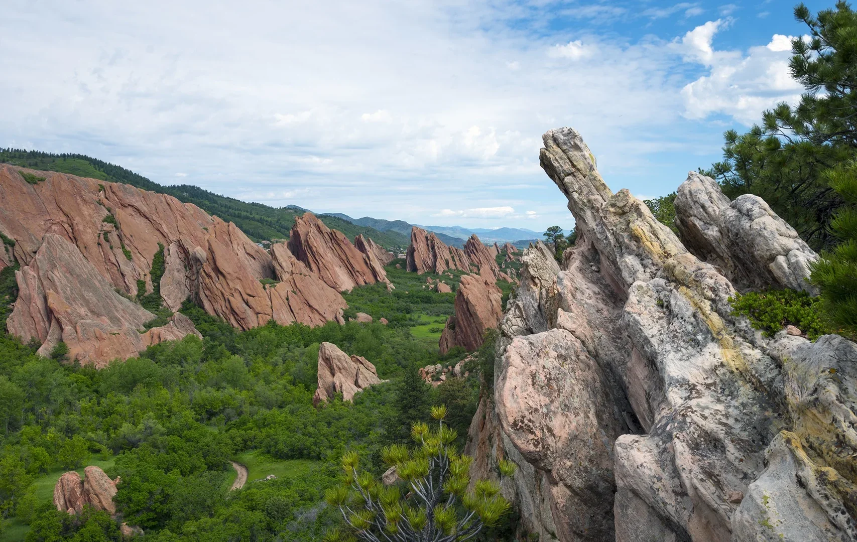
Roxborough State Park preserves one of Colorado's most pristine examples of dramatic sedimentary rock tilting, where ancient seafloor deposits now stand nearly vertical, creating knife-edge ridges that slice through the landscape. These formations represent the Fountain Formation and Lyons Sandstone, deposited between 280 and 300 million years ago when the area alternated between shallow seas and desert conditions.
The park's signature red rocks achieve their vibrant coloration through iron oxide minerals that were present when the sediments were originally deposited. Unlike many Colorado formations that were tilted gradually, Roxborough's rocks were rotated to nearly vertical positions during intense mountain-building episodes, creating the dramatic fins and ridges visible today. Some formations stand over 300 feet tall, with razor-sharp edges that demonstrate the incredible hardness of these ancient sandstones.
What makes Roxborough particularly special is its preservation of delicate geological features often destroyed by human activity. The park protects natural arches, balanced rocks, and intricate erosional patterns that reveal how water, wind, and freeze-thaw cycles sculpt solid rock over thousands of years. The Carpenter Peak Trail provides access to higher elevations where you can observe how different rock layers respond to weathering, with some forming steep cliffs while others create gentle slopes.
Wildlife viewing adds another dimension to the geological experience, as the unique rock formations create specialized habitats. Peregrine falcons nest on cliff faces, while bighorn sheep navigate seemingly impossible rocky terrain. The park's policy prohibiting rock climbing helps preserve both the formations and their wildlife inhabitants. Visit during late afternoon when the angled sunlight creates deep shadows that emphasize the three-dimensional nature of these remarkable uplifted seafloor remnants.
Black Canyon of the Gunnison National Park
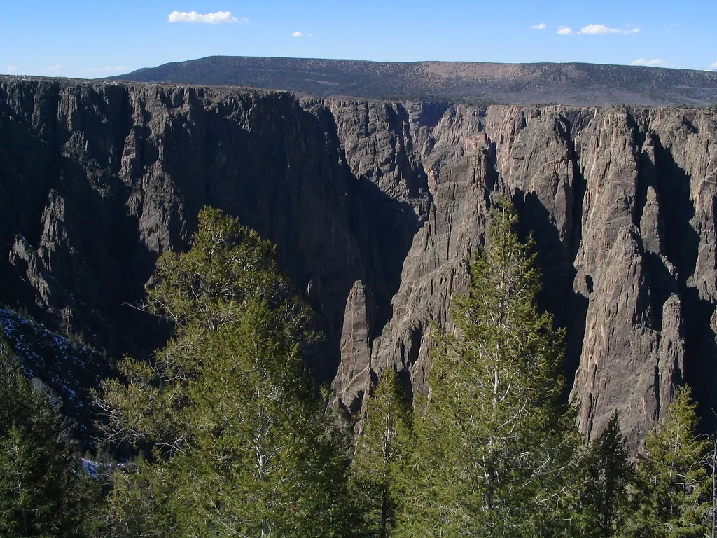
Black Canyon represents one of Earth's most impressive examples of water's ability to carve through solid rock, creating a gorge so narrow and deep that sunlight barely reaches its bottom. The Gunnison River has spent over two million years cutting through Precambrian metamorphic rock that's nearly two billion years old, creating walls that plunge over 2,700 feet while maintaining rim-to-rim distances of just 1,100 feet at the narrowest point.
The canyon's "black" appearance comes from dark metamorphic rocks that absorbed tremendous heat and pressure deep within ancient mountain ranges. These rocks—primarily gneiss and schist—contain minerals that appear nearly black when wet or in shadow, creating the ominous appearance that gives the canyon its name. Lighter-colored pegmatite veins streak through the dark rock, marking where mineral-rich fluids once flowed through fractures in the metamorphic basement.
What makes this canyon particularly remarkable is the Gunnison River's incredible cutting power. Unlike rivers that meander across landscapes, the Gunnison was essentially trapped in its course by surrounding geology, forcing it to cut straight down through some of Colorado's hardest rock. The river drops an average of 96 feet per mile through the canyon—one of the steepest gradients of any major river in North America.
The South Rim provides the most accessible viewpoints, with dramatic overlooks like Chasm View and Painted Wall View offering perspectives into the canyon's depths. Warner Point Trail leads to the park's highest viewpoint, where the full scope of this geological masterpiece becomes apparent. The North Rim offers a more wilderness experience with fewer crowds, though access requires a longer drive on unpaved roads. Winter visits can be particularly stunning, when snow emphasizes the canyon's stark geometry.
Painted Wall
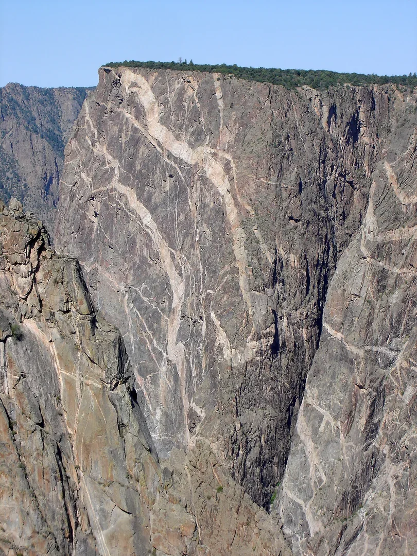
Within Black Canyon of the Gunnison, Painted Wall stands as Colorado's tallest cliff face, rising 2,250 feet from the river to rim in a nearly vertical wall that showcases some of the most complex geology in North America. This massive cliff face serves as a natural textbook, displaying rock formations that span nearly half of Earth's entire history, from 1.8-billion-year-old metamorphic basement rocks to much younger volcanic intrusions.
The "painted" appearance results from dramatic light-colored pegmatite dikes that cut through the dark metamorphic host rock in intricate patterns. These pegmatite veins formed when mineral-rich fluids were injected under tremendous pressure into fractures in the existing rock, creating the striking white and pink streaks that contrast sharply with the dark gneiss and schist. Some pegmatite dikes are over 100 feet wide and can be traced for thousands of feet across the cliff face.
The formation of Painted Wall involved multiple geological episodes spanning enormous time periods. The dark basement rocks were originally formed deep within ancient mountain ranges, then exposed and carved by the Gunnison River's relentless cutting action. The pegmatite intrusions occurred much later, during periods of intense geological activity that remobilized minerals deep within the Earth's crust.
Viewing Painted Wall requires patience and proper positioning, as the sheer scale makes it difficult to comprehend from a single vantage point. The designated Painted Wall viewpoint on the South Rim offers the classic perspective, but hiking to different positions along the rim reveals how the pegmatite patterns change appearance depending on viewing angle. Binoculars or telephoto lenses help appreciate the intricate details of this geological masterpiece, including evidence of rockfall and ongoing erosional processes that continue shaping the cliff face today.
Hanging Lake
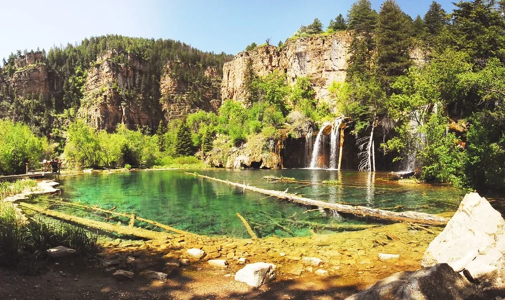
Hanging Lake represents one of Colorado's most delicate geological treasures, where a series of natural travertine dams has created an ethereal turquoise lake suspended on a cliff ledge 1,200 feet above the Colorado River. This remarkable formation demonstrates the patient work of mineral-rich water over thousands of years, building calcium carbonate deposits that create the lake's distinctive stepped appearance and impossibly blue-green coloration.
The lake formed through a process called travertine deposition, where groundwater rich in dissolved limestone emerges from springs and deposits calcium carbonate as it flows. Over millennia, these deposits built natural dams across Deadhorse Creek, creating the series of pools that culminate in Hanging Lake itself. The water's distinctive color results from finely suspended limestone particles and the lake's depth, which filters light to emphasize blue and green wavelengths.
What makes Hanging Lake particularly fragile is the ongoing nature of its formation. The travertine deposits that maintain the lake's structure are actively growing but extremely delicate. Even minor disturbances can damage formations that took thousands of years to develop. The lake's ecosystem has evolved in isolation, creating a unique environment where specialized plants grow directly from the mineral-rich deposits.
Access to Hanging Lake requires advance reservations and a challenging 1.2-mile hike that gains over 1,000 feet in elevation. The trail itself reveals the geological processes at work, passing through layers of sedimentary rock that tell the story of ancient seas and river systems. The final approach to the lake involves scrambling over the travertine deposits themselves, offering close-up views of how these formations develop. Early morning visits provide the best lighting and fewer crowds, though the lake's beauty transcends any particular time of day. Swimming and fishing are prohibited to protect the delicate formations.
Great Sand Dunes National Park and Preserve
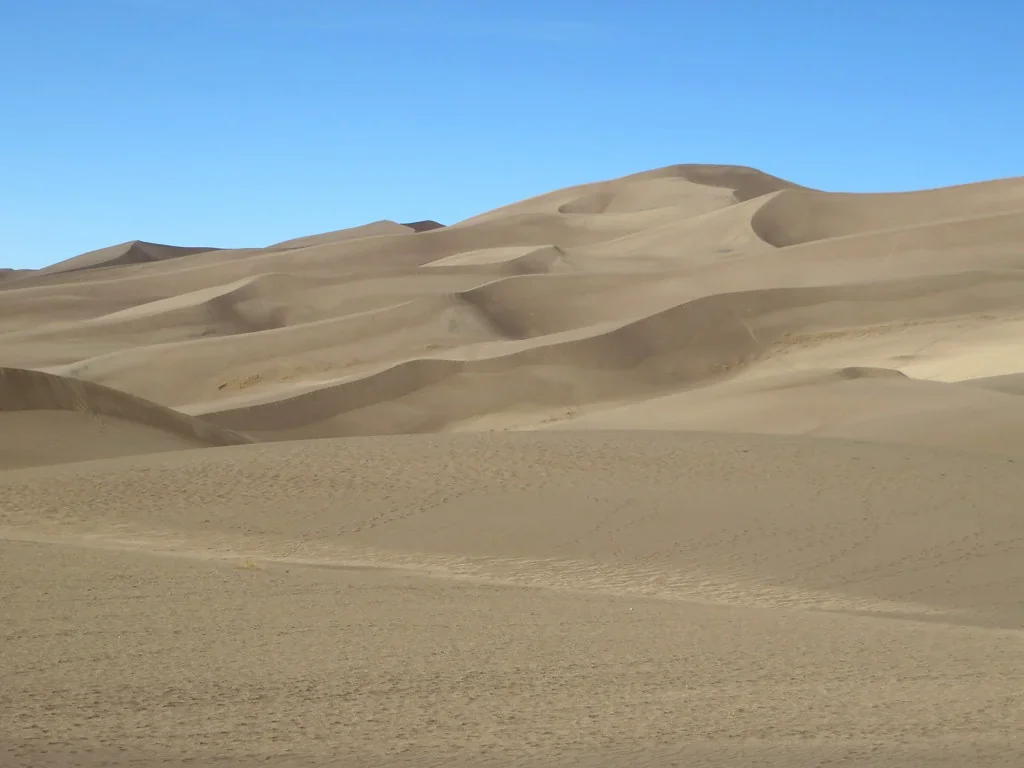
Great Sand Dunes National Park protects North America's tallest sand dunes, with Star Dune rising over 750 feet above the surrounding San Luis Valley floor. These massive formations demonstrate the power of wind to transport and sculpt granular materials over vast distances, creating a dynamic landscape that continues evolving with each storm and season.
The dunes formed through a complex interaction of geography, geology, and atmospheric conditions unique to the San Luis Valley. Sand eroded from the surrounding Sangre de Cristo and San Juan Mountains was carried by streams into the valley, then picked up by prevailing southwestern winds. When these winds encounter the Sangre de Cristo Mountains, they create a natural sand trap, depositing their load in the valley's northeast corner where the dunes continue growing today.
What makes these dunes particularly impressive is their composition and behavior. The sand consists primarily of quartz and feldspar grains that have been naturally sorted by wind action, creating the fine, uniform texture that allows the dunes to maintain such steep slopes. Different dune types are represented, from simple barchan dunes to complex star dunes that form where winds blow from multiple directions.
The dunes' surface temperature can exceed 140°F in summer, making early morning or evening visits most comfortable for exploration. Medano Creek flows seasonally at the dunes' base, fed by snowmelt from the surrounding peaks. This creates unique "surge flow" conditions in late spring and early summer, where the stream flows in waves rather than steady current due to sand dams that repeatedly form and break.
Sand sledding and sandboarding are popular activities, though the steep faces and loose sand require caution. The preserve also protects diverse ecosystems, from wetlands fed by artesian springs to alpine tundra on the surrounding peaks, creating remarkable biological diversity within sight of the towering dunes.
Dinosaur Ridge
Dinosaur Ridge preserves one of the world's most significant paleontological sites, where visitors can observe actual dinosaur tracks, fossils, and geological formations that document life during the Mesozoic Era. Located along the Dakota Hogback west of Denver, this site reveals a 100-million-year-old story written in stone, when Colorado was covered by a vast inland sea.
The ridge exposes multiple rock formations that each represent different ancient environments. The Morrison Formation contains dinosaur bones from the Late Jurassic period, including remains of Apatosaurus, Stegosaurus, and Allosaurus that lived approximately 150 million years ago. Above this, the Dakota Sandstone preserves an extraordinary trackway where Cretaceous-period dinosaurs walked across what was then a muddy shoreline.
The dinosaur tracks on the ridge's east side represent one of the most impressive displays of prehistoric footprints in North America. Over 300 individual tracks from at least four different dinosaur species are preserved in the Dakota Sandstone, including prints from large theropods, smaller ornithopods, and possibly flying reptiles. These tracks were preserved when the original mud was rapidly covered by sand, creating perfect conditions for fossilization.
What makes Dinosaur Ridge particularly valuable is its accessibility and interpretive programs. The Fossil Discovery Trail includes marked stops where visitors can observe actual fossils in their natural context, while guided tours provide expert interpretation of the geological and paleontological significance. The site also demonstrates how geological processes like tilting and erosion can expose ancient environments, making it an excellent location for understanding both paleontology and geology.
Educational programs cater to all ages, with hands-on activities that help visitors understand how fossils form and what they reveal about ancient ecosystems. The visitor center includes exhibits that place the ridge's discoveries in broader context, explaining how Colorado's landscape and climate have changed over geological time.
Glenwood Caverns Adventure Park
Glenwood Caverns Adventure Park provides access to remarkable underground formations created by water dissolving limestone over millions of years, resulting in chambers decorated with stalactites, stalagmites, and other speleothems that demonstrate the patient artistry of geological processes. These caverns formed within the Leadville Limestone, deposited approximately 350 million years ago when Colorado was covered by warm, shallow seas.
The cave system developed through a process called speleogenesis, where slightly acidic groundwater gradually dissolved the limestone along fractures and bedding planes. Over hundreds of thousands of years, this process created the network of chambers and passages visible today. The caverns' most impressive features—flowstone formations, delicate soda straws, and massive stalagmites—formed much more recently as mineral-rich water dripped and flowed through the caves, leaving behind calcium carbonate deposits.
King's Row, one of the caverns' most spectacular chambers, showcases the full range of cave formations in a single location. Massive columns stretch from floor to ceiling where stalactites and stalagmites have grown together over millennia. Delicate formations like cave pearls and rimstone pools demonstrate how even small amounts of flowing water can create intricate geological art given sufficient time.
The caverns maintain a constant temperature of 52°F year-round, making them comfortable to visit in any season. Tours range from easy walks suitable for families to challenging expeditions that explore undeveloped sections of the cave system. The Historic Fairy Caves tour follows routes used by early 20th-century visitors, while the Wild Cave tours provide opportunities to experience active speleological exploration.
Above ground, the park's location on Iron Mountain provides exceptional views of the Colorado River valley and surrounding peaks. The combination of underground geological wonders and surface vistas makes this site unique among Colorado's natural attractions, offering perspectives on both the visible landscape and the hidden processes occurring beneath our feet.


