10 Best Road Trip Routes Through Colorado
Complete guide to 10 best road trip routes through colorado. Detailed information, recommendations, and everything you need to know

Colorado's dramatic landscape transforms every mile of highway into a potential adventure, from alpine meadows dotted with wildflowers to rugged canyon walls that seem to scrape the sky. The state's road trip routes offer some of the most diverse scenery in the country, where you can experience everything from vast prairie grasslands to snow-capped peaks exceeding 14,000 feet—sometimes in the same day.
Each route tells a different story of Colorado's character. Some follow historic trading paths that connected frontier settlements, while others wind through mountain passes that challenged early miners and railroad builders. The best road trips here aren't just about reaching a destination; they're about understanding how geography shaped the communities, industries, and culture that define modern Colorado. Whether you're seeking the adrenaline rush of navigating cliff-hugging highways or the meditative calm of rolling through endless grasslands, these routes deliver experiences that stick with you long after you've returned home. Plan for weather changes, pack layers, and keep your camera ready—Colorado's roads have a way of surprising even seasoned travelers with unexpected vistas and wildlife encounters around every bend.
Trail Ridge Road
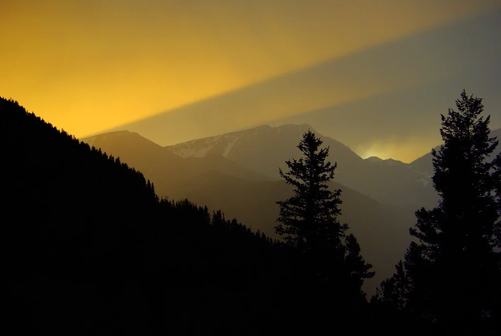
Trail Ridge Road stands as the highest continuous paved highway in North America, climbing to 12,183 feet above sea level as it crosses Rocky Mountain National Park. This 48-mile engineering marvel connects Estes Park on the east to Grand Lake on the west, spending 11 miles above the treeline where alpine tundra stretches endlessly toward distant peaks.
The road typically opens fully by Memorial Day and closes for winter by mid-October, though exact dates depend on snow conditions. Early summer brings the spectacular wildflower displays that make this dramatic storm-watching terrain even more breathtaking, with Indian paintbrush, alpine forget-me-nots, and moss campion creating vibrant carpets across the tundra. The Alpine Visitor Center, perched at 11,796 feet, provides essential context about this harsh environment where growing seasons last just six to eight weeks.
Wildlife viewing opportunities abound throughout the drive. Elk frequently graze in the meadows near the road, while bighorn sheep navigate the rocky slopes with remarkable agility. Pika and marmots inhabit the boulder fields, and golden eagles soar on thermal currents above the peaks. The best wildlife viewing occurs in early morning and evening hours.
Budget around $30 per vehicle for a seven-day park pass, or consider the annual America the Beautiful pass for $80 if you plan multiple national park visits. Gas up before entering the park—services are limited, and the high altitude reduces fuel efficiency by 10-15%. Weather changes rapidly above treeline; afternoon thunderstorms develop quickly during summer months, so start early and monitor conditions closely. The temperature drops roughly 3.5 degrees per 1,000 feet of elevation gain, meaning snow is possible any month of the year at the highest elevations.
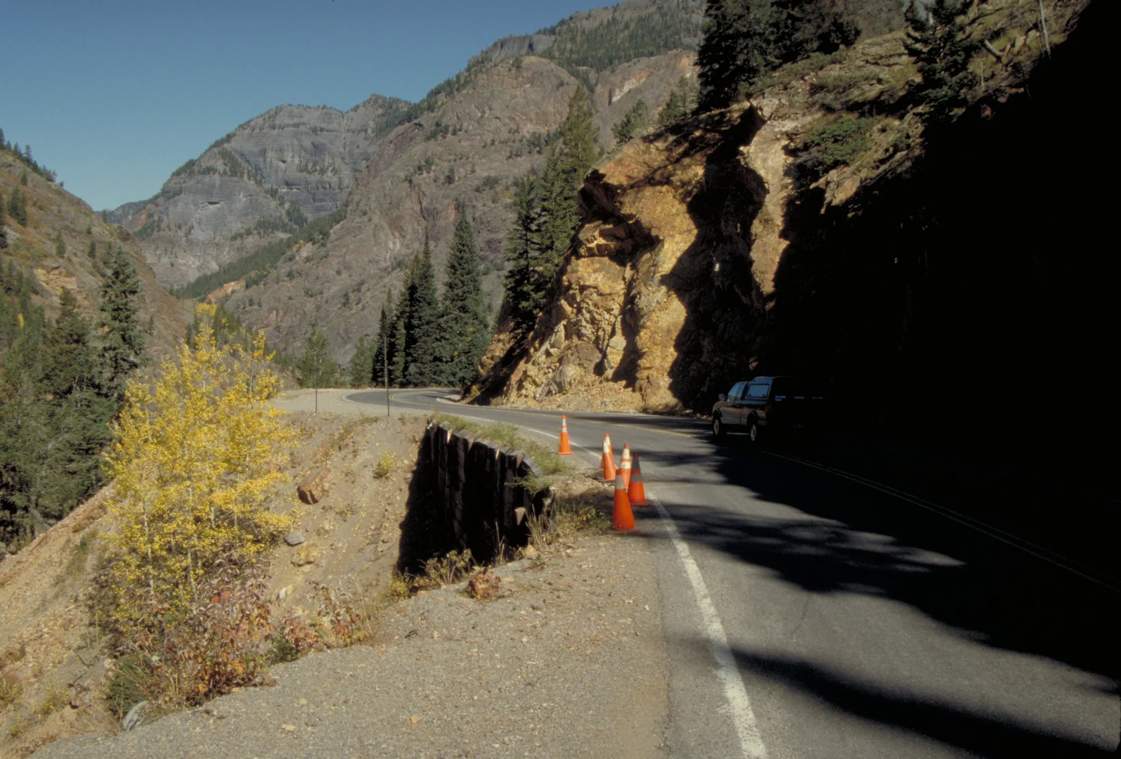
Million Dollar Highway
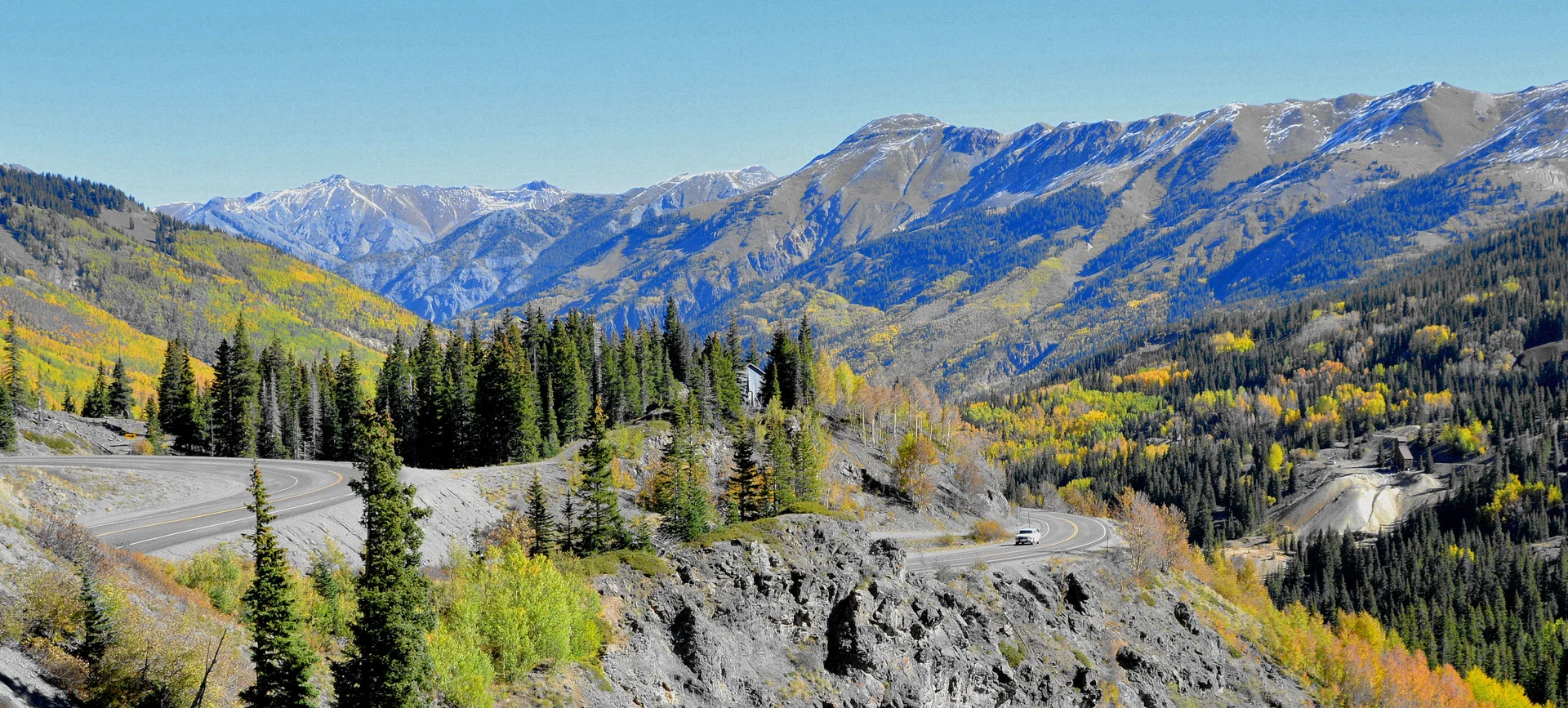
The Million Dollar Highway earned its name either from the costly construction or the million-dollar views—both explanations ring true on this spectacular 25-mile stretch of US Highway 550 between Ouray and Silverton. Built along the historic Otto Mears toll road, this route carved into near-vertical cliff faces represents one of America's most dramatic mountain drives.
The highway climbs through the Uncompahgre Gorge, where waterfalls cascade hundreds of feet down red rock walls, before ascending to Red Mountain Pass at 11,018 feet. Winter driving requires chains or four-wheel drive, and the Colorado Department of Transportation sometimes closes the pass during severe weather. Summer brings the safest conditions, though rockslides can occur year-round.
Ouray, known as the "Switzerland of America," provides hot springs for post-drive relaxation at the Ouray Hot Springs Pool. The town's Victorian architecture reflects its mining heritage, when the nearby mountains yielded millions in silver and gold. Historic hotels like the Beaumont offer authentic period accommodations, while modern amenities ensure comfort after navigating the challenging drive.
The route passes through active avalanche zones, and you'll notice the concrete barriers and snow sheds designed to protect the roadway. Red Mountain Pass showcases the area's mining legacy through abandoned structures and tailings piles, while the descent into Silverton reveals how isolated mountain communities survived harsh winters before reliable year-round road access.
Plan three to four hours for the complete drive, allowing time for photo stops and exploration. Fill up in Ouray or Silverton—no services exist between these towns. Cell phone coverage is spotty throughout the canyon, so download offline maps and inform others of your travel plans. The narrow roadway has no guardrails in many sections, making this unsuitable for drivers uncomfortable with heights or inexperienced with mountain driving.
Pawnee National Grassland
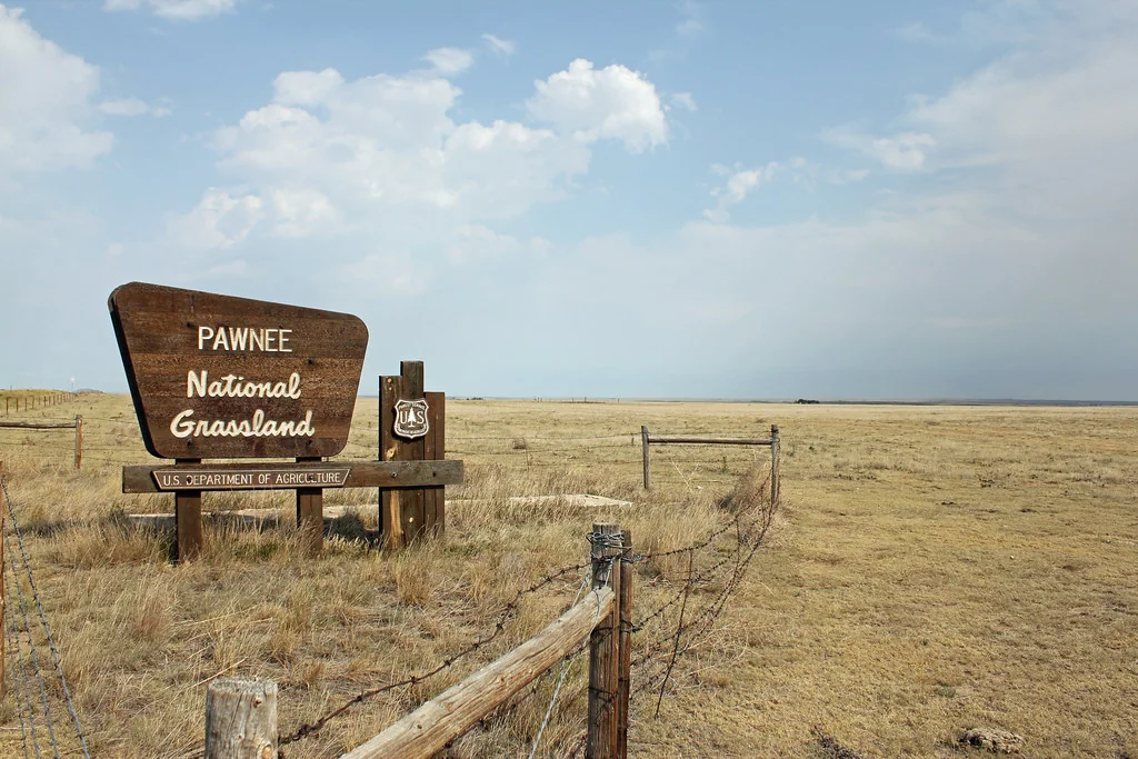
Pawnee National Grassland showcases Colorado's prairie heritage across 193,000 acres of rolling hills, native grasslands, and dramatic rock formations in the state's northeastern corner. This landscape represents the shortgrass prairie ecosystem that once covered much of the Great Plains, supporting massive herds of bison and diverse wildlife communities.
The 36-mile Pawnee Pioneer Trails Scenic and Historic Byway begins in Ault and winds through Briggsdale, passing working cattle ranches and wheat farms that demonstrate how agriculture adapted to the semi-arid environment. The route highlights the Pawnee Buttes, twin rock formations rising 300 feet above the surrounding grassland, created by millions of years of erosion that exposed layers of geological history.
Birding enthusiasts consider Pawnee National Grassland among Colorado's premier destinations. Over 300 species have been recorded here, including mountain plovers, burrowing owls, ferruginous hawks, and greater prairie-chickens. The varied habitats—from shortgrass prairie to wetlands—support different species throughout the year. Spring migration peaks in May, while breeding season extends through July.
The grassland operates under a multiple-use philosophy, balancing wildlife habitat, livestock grazing, and recreational activities. Camping is permitted throughout most areas, though facilities are primitive. The Crow Valley Recreation Area offers developed campsites, restrooms, and interpretive trails, making it ideal for families or those new to grassland camping.
Summer temperatures often exceed 90°F with intense sun exposure and limited shade, while winter conditions can be brutal with strong winds and blizzards. Spring and fall provide the most comfortable weather for hiking and wildlife observation. Always carry extra water—dehydration occurs quickly in this dry environment. GPS is essential, as roads can be confusing and cell service is unreliable across much of the grassland.
Santa Fe Trail
The Santa Fe Trail Auto Route follows portions of the historic 900-mile trade route that connected Missouri to Santa Fe from 1821 to 1880. Colorado's segment passes through the southeastern corner of the state, offering glimpses into the challenges and opportunities that shaped the American frontier.
The route enters Colorado near Holly and continues west through Lamar, Las Animas, and La Junta before heading toward Bent's Fort. This path followed the Mountain Branch of the Santa Fe Trail, chosen by traders seeking reliable water sources along the Arkansas River, despite adding miles to the journey.
Bent's Old Fort National Historic Site provides the most significant historical experience along Colorado's portion of the trail. This reconstructed 1840s trading post demonstrates how commerce brought together Native American tribes, Mexican traders, American mountain men, and frontier settlers. Living history programs throughout the summer months feature period-dressed interpreters who explain daily life at this remote outpost.
La Junta's Koshare Museum preserves Native American artifacts and traditions, while the town serves as a convenient base for exploring the region. The Santa Fe Trail tracked through what is now the downtown area, and historical markers guide visitors along the approximate route.
Comanche National Grassland surrounds much of the trail route, preserving native prairie and providing habitat for wildlife. The Picket Wire Canyonlands area contains the largest dinosaur track site in North America, with over 1,300 footprints preserved in ancient limestone.
The drive covers approximately 200 miles across Colorado, passing through small farming and ranching communities that maintain their frontier character. Summer heat can be intense, with temperatures regularly exceeding 100°F, while winter brings occasional blizzards and high winds. Spring offers wildflower displays, and fall provides comfortable temperatures for outdoor exploration. Budget for entrance fees at Bent's Fort ($15 per adult) and consider the historical significance of traveling a route that connected two nations and multiple cultures.
San Juan Skyway
The San Juan Skyway creates a 236-mile loop through some of Colorado's most spectacular mountain scenery, designated as an All-American Road for its outstanding natural and cultural significance. This route connects Durango, Silverton, Ouray, Telluride, Dolores, and Cortez, passing through multiple climate zones and elevations ranging from 6,000 to over 11,000 feet.
The clockwise journey typically begins in Durango, where Victorian architecture and the Durango & Silverton Narrow Gauge Railroad preserve the area's mining heritage. The route follows US Highway 550 north through the Million Dollar Highway section, then continues on State Highway 62 toward Ridgway and Telluride.
Telluride represents one of Colorado's premier ski destinations, nestled in a box canyon surrounded by 13,000-foot peaks. The town's isolated location preserved many original buildings from the 1880s silver boom, creating an authentic mountain atmosphere despite modern resort amenities. The free gondola connecting Telluride to Mountain Village operates year-round, providing stunning aerial views of the San Juan Mountains.
Highway 145 southwest from Telluride passes through aspen groves that create spectacular fall color displays, typically peaking in late September. The route crosses Lizard Head Pass at 10,222 feet, offering views of the distinctive Lizard Head Peak, a challenging technical climb that attracts experienced mountaineers.
The drive through Rico and Dolores showcases how geography influenced settlement patterns. Rico's narrow valley barely accommodated the town, while Dolores sits in a broader valley suitable for agriculture. The McPhee Reservoir near Dolores provides recreational opportunities and irrigation water for the region's farms.
Complete the loop takes six to eight hours of driving time, but plan at least two to three days to fully experience the communities and attractions. Accommodations range from luxury resorts in Telluride to budget motels in smaller towns. Make reservations well in advance during peak seasons—summer and fall foliage time—when lodging fills quickly throughout the region.
Flat Tops Trail Scenic Byway
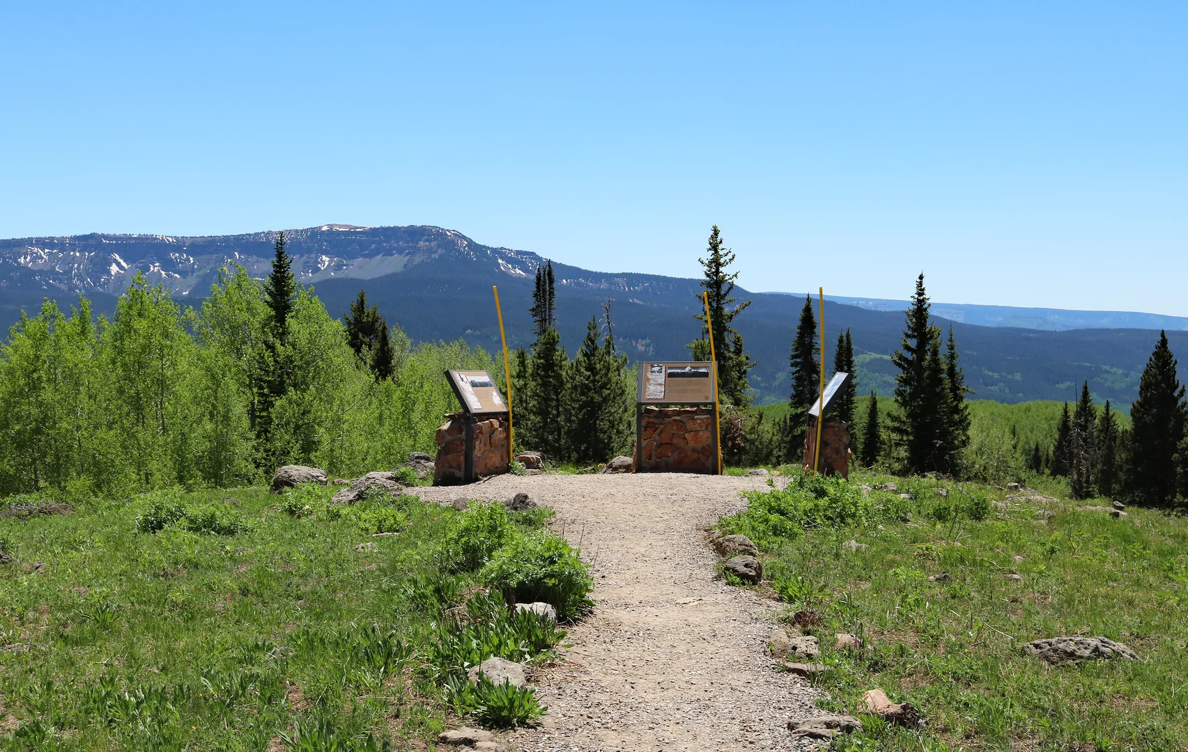
The Flat Tops Trail Scenic Byway spans 82 miles through the White River National Forest, showcasing the unique geological formations and pristine wilderness that define northwestern Colorado. This route connects Yampa and Meeker via Ripple Creek Pass, climbing through diverse ecosystems from sagebrush valleys to alpine meadows.
The Flat Tops Wilderness Area gets its name from the distinctive flat-topped mountains created by volcanic activity and erosion over millions of years. These mesa-like peaks, reaching elevations above 12,000 feet, support extensive high-altitude plateaus dotted with pristine lakes and streams. The area inspired the 1964 Wilderness Act, making it one of the original wilderness designations in the United States.
The stunning vista from Ripple Creek Overlook reveals the wilderness's scope and character, with the White River valley stretching toward distant peaks. This viewpoint provides perspective on how the Flat Tops' unique topography creates habitat for elk, deer, black bears, and numerous bird species. The overlook sits at 10,343 feet elevation, making it accessible to visitors who can't undertake extensive backcountry hiking.
Fishing enthusiasts find the Flat Tops region exceptional for brook, brown, rainbow, and cutthroat trout. The high lakes require hiking access, but roadside streams along the byway offer excellent opportunities for less mobile anglers. The White River near Meeker is particularly productive for large trout, though private land restrictions limit access in some areas.
Weather conditions change rapidly at high elevations, and snow is possible any month of the year above 10,000 feet. The byway typically remains open year-round, though winter driving requires four-wheel drive and chains. Summer brings afternoon thunderstorms that can be dangerous above treeline, while fall offers stable weather and spectacular aspen displays.
Meeker provides full services and represents one of Colorado's most authentic ranching communities. The annual Meeker Classic Sheepdog Championship Trials in September showcase the working relationship between ranchers, dogs, and livestock that continues to define the region's economy and culture.
Peak to Peak Scenic Byway
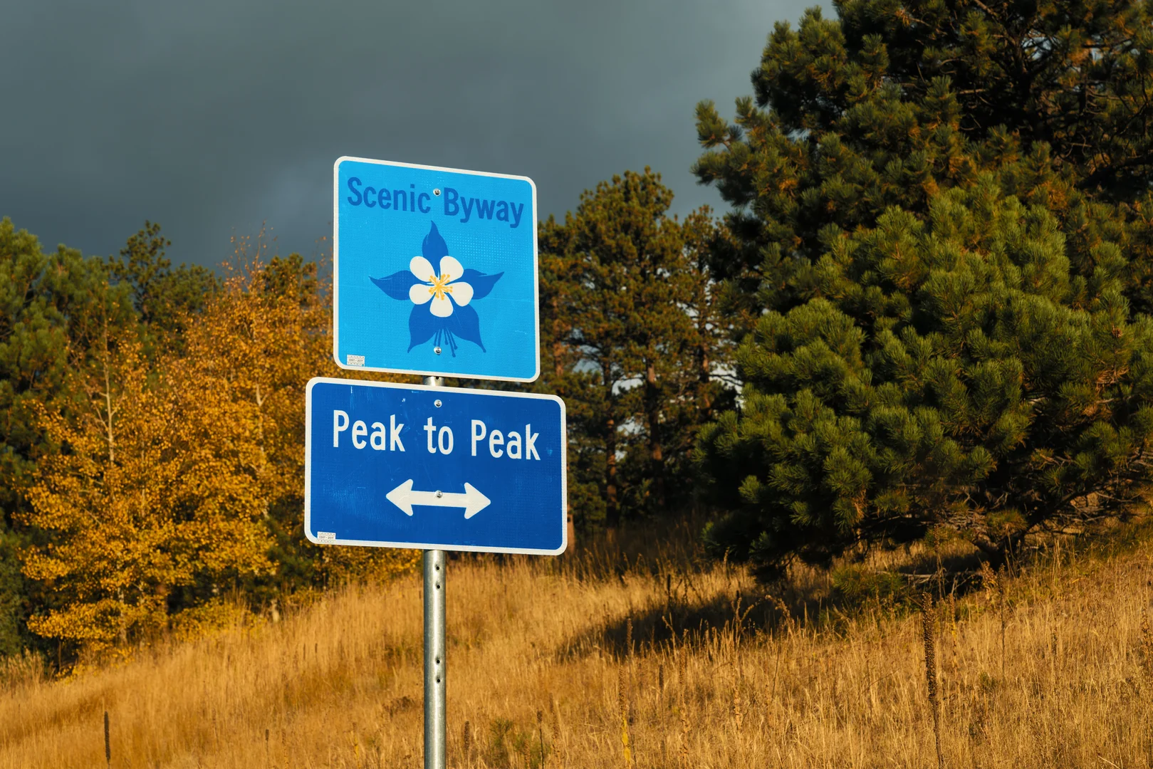
The Peak to Peak Scenic Byway stretches 55 miles along Colorado Highway 7 and Highway 72, connecting Estes Park, Nederland, and Black Hawk through the scenic foothills of the Front Range. This route provides access to multiple wilderness areas while passing through historic mining towns and modern mountain communities.
The byway begins in Estes Park, gateway to Rocky Mountain National Park, where elk commonly graze on the town's golf courses and in residential areas. The route south follows the eastern edge of Roosevelt National Forest, providing views of Longs Peak and the Continental Divide. Numerous trailheads along the highway offer hiking opportunities ranging from easy nature walks to challenging backcountry expeditions.
Nederland sits at 8,236 feet elevation, where the mining boom of the 1870s created a community that adapted to survive economic changes. The town's Frozen Dead Guy Days festival each March celebrates its quirky character, while summer brings outdoor concerts and farmers markets. Nederland serves as a hub for accessing the Indian Peaks Wilderness Area and serves as a popular base for both summer hiking and winter sports.
The route between Nederland and Black Hawk passes through Ward, a small community that maintains its mining-era character despite modern amenities. This section showcases the dramatic geological forces that created the Front Range, with exposed rock formations telling the story of ancient mountain-building processes.
Fall colors along the Peak to Peak Scenic Byway peak in mid-to-late September, when aspen groves create brilliant golden displays against the evergreen forest backdrop. This remarkable landscape draws photographers from across the region, making weekends particularly crowded during peak color season.
Ward provides access to the Brainard Lake area, where a summer shuttle system manages traffic to popular hiking destinations like Lake Isabelle and Blue Lake. Winter transforms this area into a backcountry skiing paradise, though the access road closes to regular vehicles, requiring either snowshoes or cross-country skis to reach the trails.
The southern terminus in Black Hawk offers casino gaming and historic sites related to the region's gold mining heritage. The contrast between the wilderness areas and gaming establishments illustrates how mountain communities balance natural resource preservation with economic development in the modern era.


